this is a test
Thursday, September 1, 2011
Thursday, July 7, 2011
Magnetosphere Update - Thursday July 7, 2011
http://www2.nict.go.jp/y/y223/simulation/realtime/index.html


EARTHQUAKE UPDATE

Latest Earthquakes Magnitude 2.5 or Greater in the United States and Adjacent Areas and Magnitude 4.5 or Greater in the Rest of the World - Last 7 days

New Madrid Center for Earthquake Research and Information
SOLAR UPDATE
MOON UPDATE

CAVE NEWS YOU TUBE CHANNEL
DAILY SINCE DECEMBER, 2009
http://www.youtube.com/user/CaveNews?feature=mhum
DAILY SINCE DECEMBER, 2009
http://www.youtube.com/user/CaveNews?feature=mhum

ALASKA'S HAARP FLUXGATE MAGNETOMETER
http://137.229.36.30/cgi-bin/magnetometer/gak-mag.cgi

EARTHQUAKE UPDATE
Latest Earthquakes Magnitude 2.5 or Greater in the United States and Adjacent Areas and Magnitude 4.5 or Greater in the Rest of the World - Last 7 days
Update time = Fri Jul 8 0:00:04 UTC 2011
| MAG | UTC DATE-TIME y/m/d h:m:s | DEPTH km | Region | |
|---|---|---|---|---|
| MAP | 5.2 | 2011/07/07 23:27:16 | 69.2 | KERMADEC ISLANDS REGION |
| MAP | 5.2 | 2011/07/07 21:49:18 | 24.9 | KERMADEC ISLANDS REGION |
| MAP | 2.7 | 2011/07/07 21:37:52 | 4.3 | CENTRAL CALIFORNIA |
| MAP | 5.1 | 2011/07/07 21:03:35 | 1.0 | KERMADEC ISLANDS REGION |
| MAP | 3.0 | 2011/07/07 20:03:46 | 31.2 | CENTRAL ALASKA |
| MAP | 2.5 | 2011/07/07 19:52:13 | 15.4 | CENTRAL CALIFORNIA |
| MAP | 2.6 | 2011/07/07 19:42:03 | 29.2 | PUERTO RICO REGION |
| MAP | 5.3 | 2011/07/07 19:21:48 | 5.9 | WESTERN MEDITERRANEAN SEA |
| MAP | 4.8 | 2011/07/07 19:10:44 | 156.2 | KYUSHU, JAPAN |
| MAP | 5.6 | 2011/07/07 19:08:36 | 561.3 | FIJI REGION |
| MAP | 3.0 | 2011/07/07 19:07:48 | 19.3 | SOUTH OF ALASKA |
| MAP | 4.5 | 2011/07/07 18:38:24 | 10.1 | SOUTH OF PANAMA |
| MAP | 5.6 | 2011/07/07 18:35:42 | 45.0 | EASTERN HONSHU, JAPAN |
| MAP | 3.4 | 2011/07/07 17:22:26 | 5.9 | SOUTHERN CALIFORNIA |
| MAP | 4.8 | 2011/07/07 16:31:45 | 53.3 | NEAR THE EAST COAST OF HONSHU, JAPAN |
| MAP | 5.3 | 2011/07/07 14:53:53 | 40.3 | SOUTH OF THE KERMADEC ISLANDS |
| MAP | 5.0 | 2011/07/07 13:47:02 | 29.4 | SOUTH OF THE KERMADEC ISLANDS |
| MAP | 5.3 | 2011/07/07 13:07:23 | 24.4 | KERMADEC ISLANDS, NEW ZEALAND |
| MAP | 3.2 | 2011/07/07 10:24:25 | 76.7 | CENTRAL ALASKA |
| MAP | 5.5 | 2011/07/07 09:29:58 | 22.0 | KERMADEC ISLANDS REGION |
| MAP | 6.0 | 2011/07/07 09:10:52 | 19.9 | KERMADEC ISLANDS REGION |
| MAP | 4.8 | 2011/07/07 07:10:21 | 561.1 | MORO GULF, MINDANAO, PHILIPPINES |
| MAP | 2.6 | 2011/07/07 06:36:21 | 91.8 | SOUTHERN ALASKA |
| MAP | 4.7 | 2011/07/07 06:05:21 | 19.6 | KERMADEC ISLANDS REGION |
| MAP | 4.9 | 2011/07/07 05:10:09 | 30.4 | NEAR THE EAST COAST OF HONSHU, JAPAN |
| MAP | 5.5 | 2011/07/07 04:40:17 | 19.4 | KERMADEC ISLANDS REGION |
| MAP | 4.8 | 2011/07/07 04:20:04 | 20.0 | KERMADEC ISLANDS REGION |
| MAP | 4.9 | 2011/07/07 04:02:05 | 33.9 | NEAR THE EAST COAST OF HONSHU, JAPAN |
| MAP | 4.9 | 2011/07/07 03:41:40 | 20.0 | KERMADEC ISLANDS REGION |
| MAP | 3.5 | 2011/07/07 03:27:47 | 40.1 | FOX ISLANDS, ALEUTIAN ISLANDS, ALASKA |
| MAP | 2.9 | 2011/07/07 02:12:25 | 36.1 | VIRGIN ISLANDS REGION |
| MAP | 5.0 | 2011/07/07 02:10:21 | 19.5 | KERMADEC ISLANDS REGION |
| MAP | 5.1 | 2011/07/07 01:26:39 | 19.7 | KERMADEC ISLANDS REGION |
| MAP | 4.8 | 2011/07/07 01:16:01 | 20.4 | KERMADEC ISLANDS REGION |
| MAP | 4.9 | 2011/07/07 00:51:05 | 25.6 | KERMADEC ISLANDS REGION |
| MAP | 5.2 | 2011/07/07 00:33:37 | 26.4 | KERMADEC ISLANDS REGION |
| MAP | 3.1 | 2011/07/07 00:26:44 | 131.4 | SOUTHERN ALASKA |
New Madrid Center for Earthquake Research and Information
RECENT CENTRAL STATES EARTHQUAKES
http://folkworm.ceri.memphis.edu/recenteqs/Quakes/quakes0.html
- map 1.9 2011/07/06 34 km (21 mi) SE of Canton, NY
- map 0.4 2011/07/06 5 km ( 3 mi) NNW of Delanco, NJ
- map 0.4 2011/07/06 5 km ( 3 mi) NNW of Delanco, NJ
SOLAR UPDATE

MINOR STORM WATCH: NOAA forecasters estimate a 10% chance of minor geomagnetic storms on July 7th in response to an incoming CME

Solar Update: Sunspot 1243 is producing B-Class and C-Class flares as it continues to rotate across the visible solar disk in the northern hemisphere. A couple of new sunspots have formed towards the northeast limb and one of these was numbered 1245 on Thursday. There is not yet a chance for strong solar flares around this region. Sunspot 1244 has rotated onto the western limb and out of direct earth view.
MOON UPDATE
US Dept of Homeland Security's Federal Emergency Management Agency (FEMA) Daily Update - Thursday July 7, 2011
National Situation Update: Thursday, July 7, 2011
Missouri River Basin Flooding Summary
Overview
Releases across the Missouri River Basin continue to decrease at Nebraska City and Rulo, NE; however, widespread overtopping of levees continues. Four federal levees and 11 non-federal levees have breeched or overtopped across Iowa, Kansas, Nebraska and Missouri. USACE continues to provide technical assistance and levee repairs in support of local levee sponsors responsible for the Souris and Missouri River basins.
Souris (Mouse) River Flooding – Minot, ND
Current Situation
As of 1:30 a.m. EDT on July 7, the river is at 1,556.6 feet. The flood stage is 1,549 feet. The outflow for Lake Darling measured along the Souris River was 9,170 cfs at 1:30 a.m. EDT on Wednesday, July 6, 2011. The plan for the next couple of weeks is to reduce stream flows through Minot to 3,300 cfs with anticipated discharges from Lake Darling Dam at 3,000 cfs and local inflows at 300 cfs. The goal is to reach this level of reduced stream flows at the Minot Broadway Bridge before July 19, 2011. Reconstruction of the levees/recovery will begin in mid-July, when the flow will drop to 3,000-5,000 cfs.
Minot and Sawyer (Ward County), and Velva (McHenry County), ND
All residents in the valley outside of the evacuation zone have been advised to use discretion and take precautions. The mandatory evacuations remain in effect for portions of Ward County. The residents will be allowed to return home when the level at Minot reduces to 1,555 feet. The Broadway Bridge in Minot will be open daily from 8:00 a.m.-9:00 p.m. EDT. Potable water remains a limiting factor in Minot (Ward County) with boil water orders in effect. Trinity Hospital has stretched the capacity of the National Guard supplied water purification unit. The loss of city water will likely result in the evacuation of health care facilities in Minot (Ward County).
Mandatory evacuations remain in effect for Zones 1-9 (approximately 12,000 residents)
A Mobile DRC opened on July 5, 2011 in Burlington (Ward County). Three DRCs are operational (2 in Minot and 1 in Bismarck.
North Dakota
North Dakota SEOC is at Level III (normal operations). The Garrison Dam reservoir is expected to remain nearly level for the next several days and then begin to recede. Releases have been reduced to 140,000 cfs.
Significant National Weather
Midwest
Scattered thunderstorms are expected from the eastern Dakotas to northern Michigan; some the storms could become severe with large hail and damaging winds. Heavy rain and thunderstorms are possible across northern Oklahoma, much of Kansas, and most of Missouri. Flash Flooding remains possible across much of Kansas through Friday morning.
South
Rain and thunderstorms are forecast from the Mississippi Valley eastward to Virginia, the Carolinas, and southern Florida. Some areas in Florida may see over an inch of rainfall. Western areas of Oklahoma and Texas will be hot and dry worsening current drought conditions. High temperatures will reach 100 to 105 degrees in Oklahoma and much of Texas.
West
Monsoon moisture continues to move into the region, producing isolated to scattered thunderstorms from the Sierras to southern Montana and Idaho and parts of New Mexico. Thunderstorms will also be scattered across eastern Oregon. Some of these thunderstorms could turn severe with damaging winds. Some storms in the Southwest will contain lightning and strong winds, though they will produce little rainfall. Lightning from those dry thunderstorms could produce new fires.
Northeast
Scattered thunderstorms are possible this afternoon and evening across portions of the Northeast and into the Mid-Atlantic. Some of the storms could be severe producing strong winds and hail.
Tropical Weather Outlook
Atlantic / Caribbean /Gulf of Mexico
Area 1
Disorganized cloudiness and showers over the southeastern Gulf of Mexico, southern Florida, Cuba, and the western Bahamas are associated with a surface trough and tropical wave interacting with an upper-level low. This system is expected to drift northward or northeastward with no significant development over the next couple of days. There is a low chance (10%) of this system becoming a tropical cyclone during the next 48 hours.
Eastern / Central Pacific
Area 1
Showers and thunderstorms associated with an area of low pressure located about 250 miles south of Acapulco, Mexico have changed little in organization during the last several hours. Environmental conditions are favorable for development and a tropical depression will likely form during the next day or two. There is a high chance (70%) of this system becoming a tropical cyclone during the next 48 hours as it moves west-northwest at 10-15 mph.
Western / South Pacific:
No activity expected within the next 48 hours.
Earthquake Activity
A magnitude 7.6 earthquake occurred offshore, 1,120 miles SSW of American Samoa on July 6, 2011 at 3:03 pm EDT. The depth was 12.4 miles. The earthquake generated a three foot tsunami on Raoul Island (scientific outpost). There have been no reports of damage or injuries. All tsunami warnings and watches have been cancelled.
Fire Activity
Wednesday, July 6, 2011:
National Preparedness Level: 3
Initial attack activity: HEAVY (321 new fires)
New Large Fires: 6
Large Fires Contained: 5
Uncontained Large Fires: 19
Type 1 IMT Committed: 3
Type 2 IMT Committed: 6
States affected: NM, AZ, NC, GA, FL, TX, OK, CO, NV & CA
Wildfires
North Carolina
Simmons Road Wildfire – FEMA-2936-FM-NC (approved July 4, 2011)
The fire has consumed 5,400 acres and is 50 percent contained. The evacuation order has been lifted. One shelter has been opened with nine occupants. The fire has destroyed 3 homes and 11 outbuildings.
There have been no fatalities or injuries reported.
New Mexico
Las Conchas Fire – FEMA-2933-FM-NM (approved June 26, 2011)
The fire has consumed 130,691 acres and is 40% contained. Mandatory evacuations remain in effect for Bandelier National Monument, Conchiti Mesa and Las Conchas. Voluntary evacuations remain in effect for the town of White Rock and Cochiti. Los Alamos started repopulation on July 3, 2011; no significant problems reported since repopulation began. The Federal Aviation Administration has restricted air space in the Los Alamos area to allow for airborne firefighting operations. The USACE facilities at Cochiti Lake are closed through July11, 2011.
The fire has destroyed 63 residences and 32 outbuildings. Approximately 565 residences, outbuildings and commercial buildings remain threatened. Five injuries and no fatalities have been reported.
Disaster Declaration Activity
Amendment #3 was approved to Major Disaster Declaration, FEMA-1989-DR-OK for the State of Oklahoma dated June 6, 2011. The amendment is effective July 6, 2011 to add Ottawa County for Individual Assistance.
Amendment #5 was approved to Major Disaster Declaration, FEMA-3318-EM-ND for the State of North Dakota, closes the incident period effective July 1, 2011.
Missouri River Basin Flooding Summary
Overview
Releases across the Missouri River Basin continue to decrease at Nebraska City and Rulo, NE; however, widespread overtopping of levees continues. Four federal levees and 11 non-federal levees have breeched or overtopped across Iowa, Kansas, Nebraska and Missouri. USACE continues to provide technical assistance and levee repairs in support of local levee sponsors responsible for the Souris and Missouri River basins.
Souris (Mouse) River Flooding – Minot, ND
Current Situation
As of 1:30 a.m. EDT on July 7, the river is at 1,556.6 feet. The flood stage is 1,549 feet. The outflow for Lake Darling measured along the Souris River was 9,170 cfs at 1:30 a.m. EDT on Wednesday, July 6, 2011. The plan for the next couple of weeks is to reduce stream flows through Minot to 3,300 cfs with anticipated discharges from Lake Darling Dam at 3,000 cfs and local inflows at 300 cfs. The goal is to reach this level of reduced stream flows at the Minot Broadway Bridge before July 19, 2011. Reconstruction of the levees/recovery will begin in mid-July, when the flow will drop to 3,000-5,000 cfs.
Minot and Sawyer (Ward County), and Velva (McHenry County), ND
All residents in the valley outside of the evacuation zone have been advised to use discretion and take precautions. The mandatory evacuations remain in effect for portions of Ward County. The residents will be allowed to return home when the level at Minot reduces to 1,555 feet. The Broadway Bridge in Minot will be open daily from 8:00 a.m.-9:00 p.m. EDT. Potable water remains a limiting factor in Minot (Ward County) with boil water orders in effect. Trinity Hospital has stretched the capacity of the National Guard supplied water purification unit. The loss of city water will likely result in the evacuation of health care facilities in Minot (Ward County).
Mandatory evacuations remain in effect for Zones 1-9 (approximately 12,000 residents)
- Residents in the Evacuation Zones in NE Minot protected by the secondary dike will be allowed to return when the reading at the Broadway Bridge reaches 1555 feet.
- Voluntary evacuations remain in effect for portions of Morton (182) residents and Burleigh (694 residents).
A Mobile DRC opened on July 5, 2011 in Burlington (Ward County). Three DRCs are operational (2 in Minot and 1 in Bismarck.
North Dakota
North Dakota SEOC is at Level III (normal operations). The Garrison Dam reservoir is expected to remain nearly level for the next several days and then begin to recede. Releases have been reduced to 140,000 cfs.
Significant National Weather
Midwest
Scattered thunderstorms are expected from the eastern Dakotas to northern Michigan; some the storms could become severe with large hail and damaging winds. Heavy rain and thunderstorms are possible across northern Oklahoma, much of Kansas, and most of Missouri. Flash Flooding remains possible across much of Kansas through Friday morning.
South
Rain and thunderstorms are forecast from the Mississippi Valley eastward to Virginia, the Carolinas, and southern Florida. Some areas in Florida may see over an inch of rainfall. Western areas of Oklahoma and Texas will be hot and dry worsening current drought conditions. High temperatures will reach 100 to 105 degrees in Oklahoma and much of Texas.
West
Monsoon moisture continues to move into the region, producing isolated to scattered thunderstorms from the Sierras to southern Montana and Idaho and parts of New Mexico. Thunderstorms will also be scattered across eastern Oregon. Some of these thunderstorms could turn severe with damaging winds. Some storms in the Southwest will contain lightning and strong winds, though they will produce little rainfall. Lightning from those dry thunderstorms could produce new fires.
Northeast
Scattered thunderstorms are possible this afternoon and evening across portions of the Northeast and into the Mid-Atlantic. Some of the storms could be severe producing strong winds and hail.
Tropical Weather Outlook
Atlantic / Caribbean /Gulf of Mexico
Area 1
Disorganized cloudiness and showers over the southeastern Gulf of Mexico, southern Florida, Cuba, and the western Bahamas are associated with a surface trough and tropical wave interacting with an upper-level low. This system is expected to drift northward or northeastward with no significant development over the next couple of days. There is a low chance (10%) of this system becoming a tropical cyclone during the next 48 hours.
Eastern / Central Pacific
Area 1
Showers and thunderstorms associated with an area of low pressure located about 250 miles south of Acapulco, Mexico have changed little in organization during the last several hours. Environmental conditions are favorable for development and a tropical depression will likely form during the next day or two. There is a high chance (70%) of this system becoming a tropical cyclone during the next 48 hours as it moves west-northwest at 10-15 mph.
Western / South Pacific:
No activity expected within the next 48 hours.
Earthquake Activity
A magnitude 7.6 earthquake occurred offshore, 1,120 miles SSW of American Samoa on July 6, 2011 at 3:03 pm EDT. The depth was 12.4 miles. The earthquake generated a three foot tsunami on Raoul Island (scientific outpost). There have been no reports of damage or injuries. All tsunami warnings and watches have been cancelled.
Fire Activity
Wednesday, July 6, 2011:
National Preparedness Level: 3
Initial attack activity: HEAVY (321 new fires)
New Large Fires: 6
Large Fires Contained: 5
Uncontained Large Fires: 19
Type 1 IMT Committed: 3
Type 2 IMT Committed: 6
States affected: NM, AZ, NC, GA, FL, TX, OK, CO, NV & CA
Wildfires
North Carolina
Simmons Road Wildfire – FEMA-2936-FM-NC (approved July 4, 2011)
The fire has consumed 5,400 acres and is 50 percent contained. The evacuation order has been lifted. One shelter has been opened with nine occupants. The fire has destroyed 3 homes and 11 outbuildings.
There have been no fatalities or injuries reported.
New Mexico
Las Conchas Fire – FEMA-2933-FM-NM (approved June 26, 2011)
The fire has consumed 130,691 acres and is 40% contained. Mandatory evacuations remain in effect for Bandelier National Monument, Conchiti Mesa and Las Conchas. Voluntary evacuations remain in effect for the town of White Rock and Cochiti. Los Alamos started repopulation on July 3, 2011; no significant problems reported since repopulation began. The Federal Aviation Administration has restricted air space in the Los Alamos area to allow for airborne firefighting operations. The USACE facilities at Cochiti Lake are closed through July11, 2011.
The fire has destroyed 63 residences and 32 outbuildings. Approximately 565 residences, outbuildings and commercial buildings remain threatened. Five injuries and no fatalities have been reported.
Disaster Declaration Activity
Amendment #3 was approved to Major Disaster Declaration, FEMA-1989-DR-OK for the State of Oklahoma dated June 6, 2011. The amendment is effective July 6, 2011 to add Ottawa County for Individual Assistance.
Amendment #5 was approved to Major Disaster Declaration, FEMA-3318-EM-ND for the State of North Dakota, closes the incident period effective July 1, 2011.
http://www.fema.gov/emergency/reports/2011/nat070711.shtm
Thursday July 7, 2011 - Missouri River Flooding 2011 Daily Update
NOAA | Widespread flood threat to continue through summer

Section of Burlington Northern Santa Fe BNSF track that moves coal from Lincoln, Neb., to Kansas City, Mo., is under water because of Missouri River flooding

http://www.siouxcityjournal.com/news/state-and-regional/article_1960a5ba-a7d8-11e0-af88-001cc4c002e0.html
RadiationNetwork.com

Updated in real time every minute. This is the first web site where the average citizen (or anyone in the world) can see what radiation levels are anywhere in the USA at any time
NOAA Hydrologic - Water Level at Gavins Point Dam, near Ft. Calhoun and Cooper Nuclear Plants

(The following link takes a bit to load all data)
http://water.weather.gov/ahps2/river.php?wfo=oax&wfoid=18705&riverid=203276&view=1%2C1%2C1%2C1%2C1%2C1%2C1%2C1&toggles=10%2C7%2C8%2C2%2C9%2C15%2C6&pt[]=141614&pt[]=144183&pt[]=142396&pt[]=143355&allpoints=143990%2C145585%2C145025%2C145026%2C144876%2C145027%2C143234%2C143184%2C145519%2C145640%2C144217%2C142150%2C142780%2C142853%2C145202%2C141586%2C144582%2C143543%2C144796%2C144098%2C144240%2C141320%2C141614%2C142968%2C144183%2C142574%2C143478%2C142193%2C142760%2C142003%2C142610%2C142396%2C144496%2C147345%2C141899%2C143355%2C142050%2C141570%2C144165%2C143476%2C141703%2C142023%2C144123%2C141863%2C143539%2C143436%2C141917%2C143009%2C142688%2C142640%2C143925%2C143734%2C142729%2C141978%2C143579%2C143348%2C142822&data[]=all&submit=Make+my+River+Page%21#bron1

BLAIR, NEBRASKA NEAR FT. CALHOUN NUCLEAR POWER PLANT

BROWNVILLE, NE - NEAR COOPER NUCLEAR PLANT

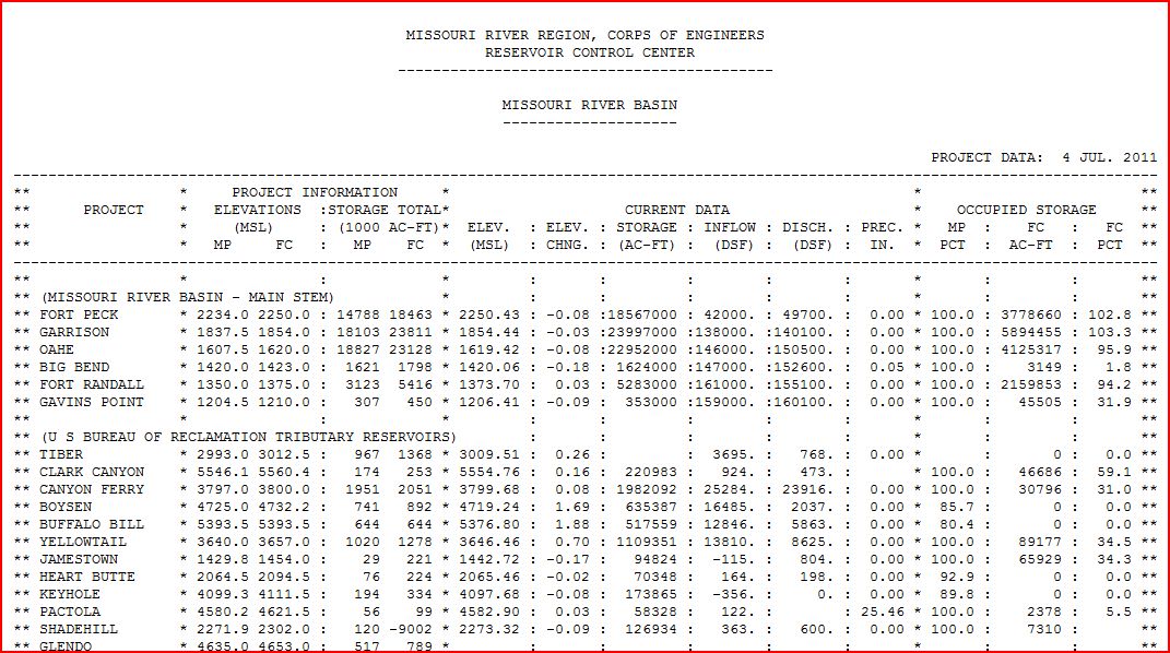
RESERVOIR CONTROL CENTER REPORTS
The following is the latest Reservoir Readings on the Upper Missouri River. This report is updated daily. Click on the picture for today's readings in reference to Gavins Point Dam, Ft. Randall Dam in SD, Big Bend Dam in SD, Oahe Dam in SD, Garrison Dam in ND and Fort Peck in Mt.
Link to daily report:
http://www.nwd-mr.usace.army.mil/rcc/reports/showrep.cgi?3MRDTAP7Link to daily report:
The Cave's Archive: NW DIVISION OF THE US ARMY CORPS OF ENGINEERS RESERVOIR CONTROL CENTER DAILY REPORT


Link: THE CAVE'S OVERFLOW - Archive of the Cave's Daily Flood of 2011 Updates
Wednesday, July 6, 2011
Wednesday July 6, 2011 - Missouri River Flooding 2011 Daily Update
Officials watch Missouri River in North Dakota after Yellowstone River oil spill in Montana - 6 Major pipelines cross the Missouri River
The six major pipelines that cross the Missouri River system are the Williston Basin Interstate Pipeline (natural gas) and the NuStar Energy Pipeline (refined crude oil products), both north of Bismarck under the Missouri River, a Cenex-owned pipeline carrying refined crude from Montana carried over the Missouri River on the 4 Bears Bridge at New Town, and the Dakota Gasification Company's carbon-dioxide pipeline and the Tesoro crude Pipeline, both under Lake Sakakawea.

Bismarck Tribune | Posted: Tuesday, July 5, 2011 11:11 pm
Cleanup crews work to clear oil from along side the Yellowstone River in Laurel, Mont., on Tuesday. The Yellowstone River swelled above flood levels Tuesday, raising fears that the surge will push thousands of gallons of oil spilled from a broken pipeline into undamaged areas and prolong cleanup efforts as crude seeps downstream and into back channels.
An oil spill into the Yellowstone River could eventually run into the Missouri River, and state health officials took water quality samples near Williston on Tuesday to look for volatile compounds and hydrocarbons.
Friday's spill of a reported 42,000 gallons of oil from a broken ExxonMobil pipeline near Laurel, Mont., was visible 50 miles downstream in the Yellowstone River on Tuesday, said State Health Department Water Quality Division director Dennis Fewless.
He said at the present rate of flow - about 70,000 cubic feet per second - Yellowstone River waters from Laurel would reach the confluence with the Missouri River near Williston by midnight on Tuesday, although it's not clear if any of the oil plume would also be carried that far so quickly.
Fewless participated in a conference call on Tuesday morning with Montana officials and the federal Environmental Protection Agency. They reported that about 200 people were working to clean up the spill with absorbent pads and booms.
Fewless said the high water levels in the Yellowstone River are pushing water out onto vegetated flood plains, where oil is easier to capture than out in the main channel.
"We'll grab samples (in Williston) as a precaution, but I don't anticipate a problem," Fewless said.
The Missouri River is the water source for Williston, but the intake is not on the surface where any oil would float, he said.
Even though the oil appears to be pooling hundreds of miles upstream of the two rivers' confluence, Fewless said he'll get a quick turn-around of Tuesday's water samples for comparison.
The incident underscores the need for equipment and training to handle an oil spill in water in North Dakota, where an oil well spill north of Keene impacted Lake Sakakawea this spring
Fewless said state and federal environmental officials have been meeting with the State Industrial Commission and the oil industry to talk about how and where to gear up for an oil-in-water spill with the right boat and boom assets and response time.
"A lot of work is being done. By Sept. 1, I expect there'll be a lot in place in North Dakota," Fewless said.
Justin Kringstad, director of the North Dakota Pipeline Authority, said there are six pipelines that cross either Lake Sakakawea or the Missouri River and a larger cluster that cross the Little Missouri River. He said safety statistics compiled by the federal Department of Transportation Pipeline and Hazardous Materials Safety Administration show North Dakota's pipelines so far have a "very good" safety record.
The Safety Administration's statistics show that over the decade ending in 2010, there have been an average of two pipeline spills each year, of an average 4,600 barrels, causing about $1 million in property damage.
So far, those haven't affected a major stream, lake, or river.
Fewless said recent pipeline spills into waterways have been from gathering lines from oil wells. Those were a 5-barrel spill into Horse Creek and a
40-barrel spill into Spring Creek, both in Bowman County, and both ephemeral streams that run only with snowmelt or rain runoff.
"We've never had anything of this (Yellowstone River) magnitude," Fewless said.
The six major pipelines that cross the Missouri River system are the Williston Basin Interstate Pipeline (natural gas) and the NuStar Energy Pipeline (refined crude oil products), both north of Bismarck under the Missouri River, a Cenex-owned pipeline carrying refined crude from Montana carried over the Missouri River on the 4 Bears Bridge at New Town, and the Dakota Gasification Company's carbon-dioxide pipeline and the Tesoro crude Pipeline, both under Lake Sakakawea.
Fewless said he will receive regular updates on the Yellowstone River spill.
http://www.bismarcktribune.com/news/state-and-regional/article_3abf0cde-a787-11e0-8938-001cc4c03286.html
Corps of Engineers issued an announcement declaring that monthly run-off into the Upper Missouri River Basin was the highest on record, dating back to 1898

http://www.aberdeennews.com/news/aan-deluges-in-may-june-set-record-flow-on-missouri-river-20110705,0,4921542.story
Sen. Ben Nelson, D-Neb., said Tuesday that the US Army Corps of Engineers has responded to his call to make Nebraska's nuclear power plants a top consideration amid Missouri River flooding
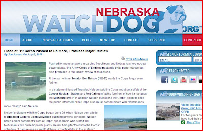
http://nebraska.watchdog.org/15504/flood-of-11-corps-pushed-to-do-more-promises-major-review/
Florida Attorney Demands Shut Down of Cooper Nuclear Station in Nebraska
Updated: 3:57 AM Jul 6, 2011
Brownville, Neb.
Thomas Saporito is a consultant, based out of Florida. He said with flood water surrounding the plant, a nuclear meltdown is bound to happen. Saporito wants the Nuclear Regulatory Commission, or NRC, to take swift action.
Saporito is afraid a meltdown will mirror the horrible one in Japan. He claims if the water rises anymore - it'll cause a dominoe affect.
That effect will shut down the Off-Site Power and the Emergency Diesel Generator. In turn, he said the water will be contaminated.
Saporito said the plant should be shut down immediately .He wants the NRC to pull the plug and charge Cooper Nuclear a fine of $1-million.
"Cooper Nuclear Station is operating safely and the site is built 13 feet above natural grade. In addition, the stations design protects the plant from these flood waters. We've also taken additional measures to protect against even higher river levels" - Jeanne Scheiffer, Corporate Communications, Nebraska Public Power District.
"They've already played their hand out and showed the public a flagrant disregard for public health and safety, in the dire consequences the place is facing right now," Saporito said.
On the flip side of that coin, the NRC Chairman Greg Jaczko recently visited the plant and said he saw no immediate threat.
10/11 spoke with reps from the Nebraska Public Power District. It owns Cooper Nuclear.
They said if waters surrounding the plant reach 45. 5 feet, they have to shut it down. As it stands, flood waters are at 42. 3 feet.
Governor Dave Heineman said this:
"The Chairman of the NRC was here about a week or 10 days ago. He said it was safe. Executive Leadership of both those plants said that, so I trust their judgement. We're going to monitor it very very closely."
The NRC's Public Review Board will hold a public hearing on Saporito findings. From there it could go to the NRC.
http://www.1011now.com/home/headlines/Advocate_Demands_Shut_Down_of_Cooper_Nuclear_125044024.html
RadiationNetwork.com
Updated in real time every minute. This is the first web site where the average citizen (or anyone in the world) can see what radiation levels are anywhere in the USA at any time
NOAA Hydrologic - Water Level at Gavins Point Dam, near Ft. Calhoun and Cooper Nuclear Plants
(The following link takes a bit to load all data)
http://water.weather.gov/ahps2/river.php?wfo=oax&wfoid=18705&riverid=203276&view=1%2C1%2C1%2C1%2C1%2C1%2C1%2C1&toggles=10%2C7%2C8%2C2%2C9%2C15%2C6&pt[]=141614&pt[]=144183&pt[]=142396&pt[]=143355&allpoints=143990%2C145585%2C145025%2C145026%2C144876%2C145027%2C143234%2C143184%2C145519%2C145640%2C144217%2C142150%2C142780%2C142853%2C145202%2C141586%2C144582%2C143543%2C144796%2C144098%2C144240%2C141320%2C141614%2C142968%2C144183%2C142574%2C143478%2C142193%2C142760%2C142003%2C142610%2C142396%2C144496%2C147345%2C141899%2C143355%2C142050%2C141570%2C144165%2C143476%2C141703%2C142023%2C144123%2C141863%2C143539%2C143436%2C141917%2C143009%2C142688%2C142640%2C143925%2C143734%2C142729%2C141978%2C143579%2C143348%2C142822&data[]=all&submit=Make+my+River+Page%21#bron1

BLAIR, NEBRASKA NEAR FT. CALHOUN NUCLEAR POWER PLANT

BROWNVILLE, NE - NEAR COOPER NUCLEAR PLANT

RESERVOIR CONTROL CENTER REPORTS
The following is the latest Reservoir Readings on the Upper Missouri River. This report is updated daily. Click on the picture for today's readings in reference to Gavins Point Dam, Ft. Randall Dam in SD, Big Bend Dam in SD, Oahe Dam in SD, Garrison Dam in ND and Fort Peck in Mt.
Link to daily report:
http://www.nwd-mr.usace.army.mil/rcc/reports/showrep.cgi?3MRDTAP7Link to daily report:
The Cave's Archive: NW DIVISION OF THE US ARMY CORPS OF ENGINEERS RESERVOIR CONTROL CENTER DAILY REPORT

Link: THE CAVE'S OVERFLOW - Archive of the Cave's Daily Flood of 2011 Updates
Subscribe to:
Posts (Atom)